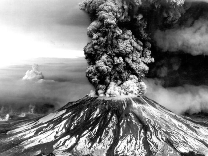
Today marks forty-six years since the most catastrophic volcanic disaster in U.S. history took place. At 8:32AM on May 18, 1980, after a two-month-long series of earthquakes, a sizable 5.1 earthquake caused most of the northern face of Mt. St. Helens to collapse, immediately leading to the eruption of the volcano and a subsequent series of disasters. The eruption would last nine hours, but the effects would last for years.
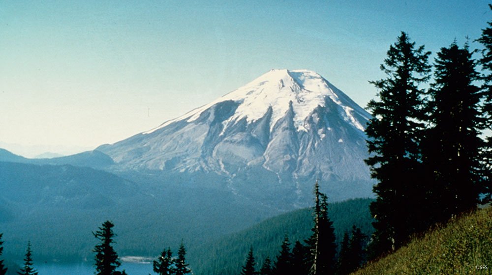
Mt. St. Helens sits in the Cascade Mountain range, a range which is formed by the west side of the North American Continental Plate. The edge of this plate rests on top of the Juan de Fuca Oceanic Plate. As the North American Plate moves westward over the east-moving Juan de Fuca Plate, the two massive pieces of the Earth’s crust build up unimaginable pressure in between as the bottom plate begins to melt under the intense heat and builds up high-pressured gases.
Eventually, the pressure had to go somewhere, and the plates shifted causing earthquakes. The earthquake on May 18, 1980 was disruptive enough that the pressure underneath Mt. St. Helens had no option but shoot up and out. While the earthquake itself wasn’t necessarily horrific, it was just enough to initiate the release of gases and other molten materials. This eruption was so catastrophic that the northern face of the volcano essentially disintegrated and collapsed and blew out simultaneously. According to the NOAA, “the eruption produced a force equal to 10–50 megatons of TNT, the equivalent of 25,000 atomic bombs released over the city of Hiroshima during World War II, and super-heated gas and rock exploded out of the volcano sideways at speeds of up to 400 mph.”
Six miles away, United States Geological Survey volcanologist, David A. Johnston, was stationed at his post north of the mountain at the time of the eruption. Once the volcano blew, Johnston had just enough time to radio in to his colleagues, “Vancouver! Vancouver! This is it! Vancouver, is the transmitter on?”, a message recorded by a relatively nearby amateur radio operator. The initial blast, which began at 220 MPH and eventually sped up to 670 MPH, reached Johnston in just 54 seconds.
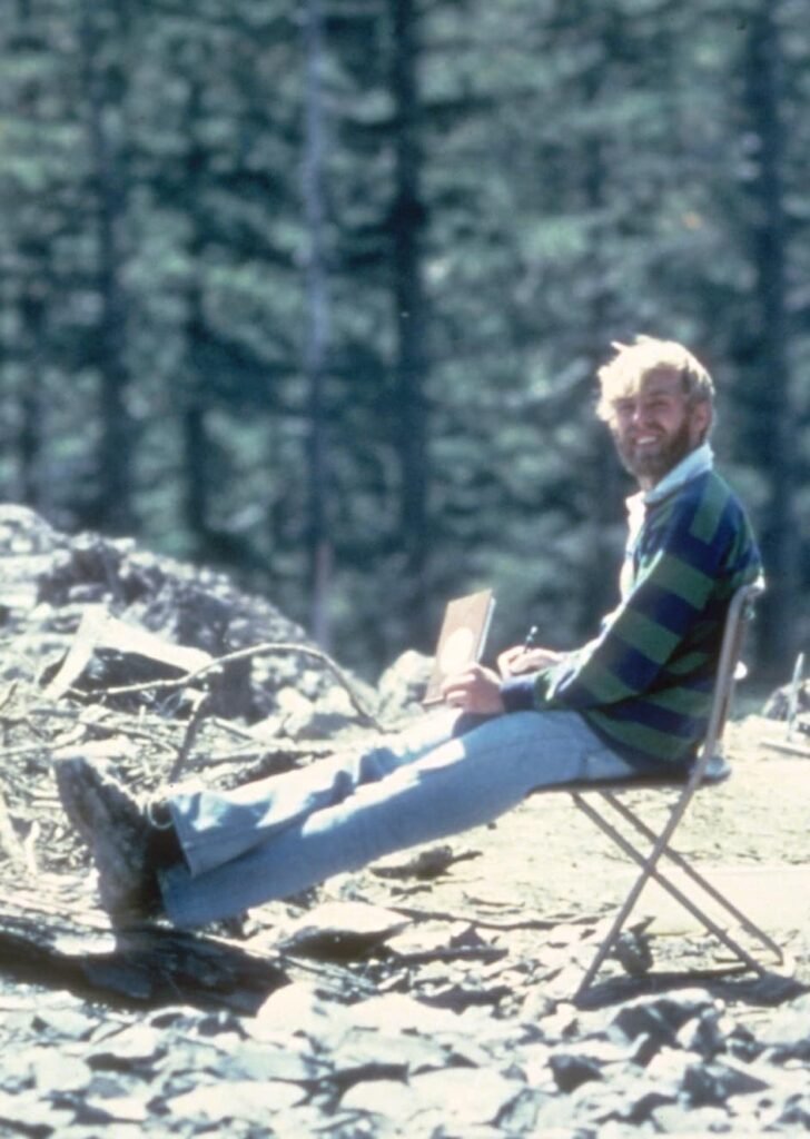
While Johnston’s body was never recovered, parts of his camper were located thirteen years later in 1993 while construction workers were building the Spirit Lake Memorial Highway extension which led to the Johnston Ridge Observatory (named in memory of Johnston).
Another nearby amateur radio operator, Gerry Martin who was set up approximately one mile further north than Johnston, witnessed Johnston’s post get wiped out. Martin was able to radio in his own final words, “Gentlemen, the camper and the car that’s sitting over to the south of me is covered. It’s going to hit me, too.” From the time Johnston’s post was wiped out to the time the blast reached Martin was approximately 11 seconds.
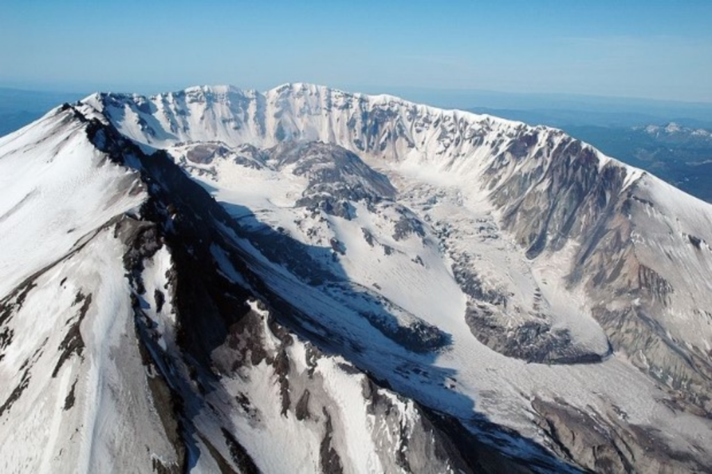
The immediate effects of the eruption reduced the mountain’s height by 1,300 feet, left a 1 to 2 mile wide crater, destroyed 200 homes, 47 bridges, 15 miles of railways, 185 miles of highway, deposited ash in 11 states and 5 Canadian provinces, destroyed over 4 billion board feet of timber, thousands of big game animals, millions of salmon fingerlings, and resulted in a total of $1.1 billion in property damage ($3.4 billion adjusted for 2023).
However, arguably the greatest losses were the 57 men, women, and children who died as a direct result of the Mt. St. Helens eruption.

Links you may be interested in:
LIVE Webcam of Mt. St. Helens from Coldwater Lake
Mt. St. Helens Science and Learning Center Image Gallery
The Story Behind That Photo Of The Pinto In Front Of The Mt. St. Helens Eruption